
Key Takeaways
- Discover hidden gems of cycling routes beyond the usual tracks
- These paths offer unique landscapes and unforgettable experiences
- Expert-selected trails promise adventure for every kind of cyclist
Imagine pedaling along a path where each turn is a fresh view worthy of a postcard.
Got your attention?
Bicycling is not just about reaching a destination; it’s about soaking in the unique beauty that each path has to offer. ** Boldly venture beyond your local bicycle path—you might be surprised by the world's hidden treasures.
From tracing the veins of ancient civilizations to chasing the horizons of modern landscapes, these paths are a cyclist's dream. ** Trust us, you’re about to discover routes that transform a simple ride into a breathtaking adventure.
We’ve scouted paths that meander through emerald greenways, dive into historic tunnels, and climb beside towering glaciers.
Let’s journey together through secret routes and under-the-radar trails that are sure to leave you inspired for your next cycling quest.
The Route of the Hiawatha, USA

Have you ever wished to ride through a landscape so breathtaking it feels like a secret passage reserved just for you?
Let's talk about the Route of the Hiawatha, an enchanting bike path tucked away in the Bitterroot Mountains between Idaho and Montana.
Essential Details:
- Season: May 24 – September 15, 2024
- Hours: 8:30 AM – 4:15 PM midweek; 8:30 AM – 5:00 PM daily
- Contact: 208.744.1234
This magnificent trail was once a railroad, and now it’s your path to adventure.
Imagine pedaling across sky-high trestles and plunging into eerie tunnels; this trail has all that and more.
It's not just a workout for your legs but a feast for your eyes.
What to Expect:
- Tunnels: Exhilarating rides in the cool darkness
- Trestles: Incredible views from high above the ground
- Scenery: Lush forests and rugged mountain vistas
Good to Know:
- Located near Wallace, Idaho.
- The trail stretches over 15 miles.
- Named a "Hall of Fame" trail by the Rail-to-Trail Conservancy.
And hey, don't worry if you haven't packed a snack; there’s food for sale at both ends of the trail.
Need a break or some insight into the history?
You'll find interpretive signs all along your ride.
Plus, if you're bringing a troop of 15 or more, you'll snag a 10% discount on trail, shuttle, and bike rentals — savings never hurt, right?
So grab your helmet, and let’s hit the trail that will surely become the highlight of your cycling escapades.
Remember, the best time to ride the Hiawatha Trail is during the official season, so mark those calendars!
The Greenway of the Giants, Northern Ireland
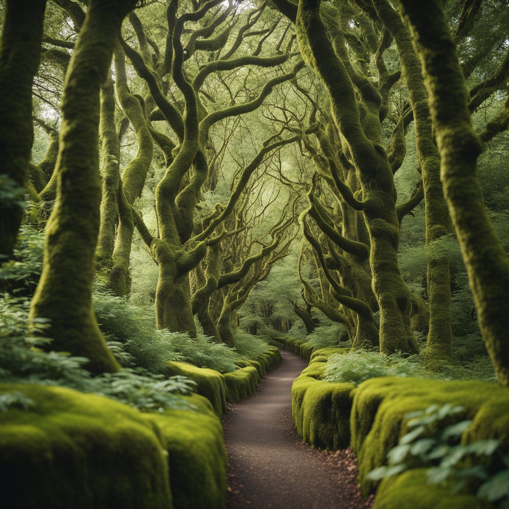
Are you ready for a ride like no other?
Imagine pedaling through landscapes so lush and mythical, they seem to spring from the pages of a fairytale.
Welcome to The Greenway of the Giants in Northern Ireland, a hidden gem that will leave you breathless – and not just from the cycling!
-
Starting Point: Set off from the charming seaside town of Ballycastle.
-
Distance: Your journey stretches approximately 56 miles to the Giant's Causeway.
-
Terrain: Expect a delightful mix of:
-
Exposed rolling hills
-
Challenging steep climbs
-
Relaxing flat farmland stretches
-
Stunning coastal roads
Have you ever seen the Dark Hedges on TV?
Well, this path winds through that exact magical corridor of beech trees made famous by "Game of Thrones".
Have your camera ready – this is a photo op you won't want to miss.
Think that's impressive?
The route also leads you on a coastal tour where you'll witness the majesty of the Giant's Causeway—an area of about 40,000 interlocking basalt columns resulting from an ancient volcanic eruption.
It’s not just a ride; it’s an adventure through some of Northern Ireland's finest scenery:
Whether you're cycling solo, with friends, or with family, there's something to make you gasp in wonder.
Ready to conquer both terrain and tales?
Strap on that helmet and take on The Greenway of the Giants.
Your storybook ride awaits!
The Flume Trail, USA

Ever craved an unforgettable bike ride with views that'll have you stopping in your tracks?
Well, the Flume Trail in Nevada should be on your radar!
Imagine pedaling along with Lake Tahoe's brilliant blue waters on one side and the impressive Sierra Nevada mountains on the other.
Got your attention yet?
What To Expect:
- Starting Point: Spooner Lake State Park
- Finish: The cafe at your rental shop
- Distance: 14 miles (most popular version)
Highlights:
- Marlette Lake Overlook: Snap some photos; the view is amazing!
- Tunnel Creek Road Descent: A thrilling downhill to end your ride
Preparing for the Flume Trail means making a bit of a climb— there's a 4-mile stretch that ascends 1,000 ft., which some find challenging.
But trust me, your efforts are rewarded with sights that are nothing short of majestic.
Here's a quick rundown:
- Duration: Half-day adventure
- Difficulty: Moderate (that initial climb though!)
- Best Time to Visit: Spring through Fall for the best conditions
Make sure to reserve your shuttle when planning your trip, because after that invigorating descent, you'll want an easy ride back to start.
Tips for Your Trip:
- Hydration is key, bring plenty of water!
- Don't forget your camera; every turn is a postcard-worthy moment.
Can't wait to see you out there, enjoying one of North Lake Tahoe's hidden gems.
Just keep pedaling, and remember, it's about the journey, not just the destination!
Ciclovia de los Presos, Argentina

Have you ever cycled where prisoners once treaded?
In Ushuaia, the southernmost city in the world, you'll find a less-trodden bikeway with a storied past—the Ciclovia de los Presos.
Imagine riding along the same route that prisoners used to journey, surrounded by the stunning landscape of Tierra del Fuego.
Let's break it down a bit, shall we?
- The Route: Your adventure starts on the outskirts of Ushuaia, where this bike path twists through pristine forests. It follows the old train tracks which prisoners used for transporting firewood. It's a journey through both nature and time.
- History Meets Scenery: The ride isn't just about pedal power; it's a cultural immersion. You're retracing the steps of the past, with every turn offering a story and a view. Plus, the trail is part of the local heritage, adding layers of meaning to each pedal stroke.
- Accessibility: Don't worry if you're not a seasoned cyclist; the path welcomes all fitness levels. It's an inclusive experience, ensuring nobody misses out on this unique blend of culture and natural beauty.
So, grab your bike and take a spin through history!
And hey, isn't it cool to say you've biked at the end of the world?
Otago Central Rail Trail, New Zealand

Have you ever wanted to cycle through history?
With the Otago Central Rail Trail, you can do just that in New Zealand's Central Otago region.
Let's dive into what makes this trail a delightful surprise:
- Length: 152 km
- Start & End Points: Clyde to Middlemarch
- Trail Type: Grade 1, impeccable for all skill levels
Embark on a journey through the landscape that is as rich in history as it is in beauty.
Imagine pedaling along a path where steam locomotives once chugged, carrying gold miners to their dreams during the gold rush era.
Isn't that something!
What Will You See?
- Rugged landscapes and vast skies that stretch as far as the eye can see.
- Historic gold-mining towns, where charming locals are eager to share stories.
Why Choose This Trail?
- No Traffic: It's just you, your bike, and nature.
- Hospitality: Experience the famous Southern hospitality firsthand.
- Wine and Cuisine: Savour local flavours that are as delightful as the views.
Imagine riding through tunnels hewn from rock and over bridges spanning crystal-clear rivers.
All while under the expansive skies that Central Otago is famed for.
What's the best part?
You set the pace.
Whether you complete the trail over several days or take it section by section, the Otago Central Rail Trail is tailor-made for memories.
So, grab your bike and come join a community of riders who've discovered this wonderful, open secret.
After all, isn't life all about finding new paths to explore?
The Rallarvegen, Norway

Ever imagined pedaling your way through Norway's breathtaking high-mountain landscapes?
The Rallarvegen might just be your dream come true!
Winding alongside the historic Bergen Railway, this trail is not just about exercise; it's a full-on nature immersion.
Quick Facts:
- Difficulty: Intermediate
- Length: 81 km (Haugastøl to Flåm)
- Elevation: 1,192 m ascent; 2,161 m descent
- Starting Point: Haugastøl
Getting there is a snap; take the train or bus to Haugastøl and set off from there.
As you kick off your journey, you're treated to a visual feast: the route flaunts an array of mountains, waterfalls, and even glimpses of icy glaciers!
Did you know this road has a past?
It traces the same paths laborers carved during the railway construction around 1900.
Are you ready for the highlights?
From Finse, at a lofty 1,222 meters, you'll swoop down to the sea level at Flåm, experiencing a thrilling descent!
Don't rush, though.
Take your time to savor the wooden signposts and the stories they tell.
- Most Popular Section: Finse to Flåm
- Map to Grab: Rallarvegen Bicycle Map 1:50,000
Remember, you're traveling through open terrain, so pack layers and be ready for any weather.
Look out for cozy accommodations along the way if you decide to make a pit stop and absorb the highland tranquility.
Fancy a memorable ride?
The Rallarvegen is revered as a jewel among Norway's cycle routes, and it's waiting for you.
Bike, nature, history—what more could you ask for?
Grab your helmet, and let's ride!
La Route Verte, Canada

Have you ever dreamed of cycling through a vast, beautiful province, where the trails weave into the very fabric of the land?
Let's take a ride through La Route Verte, Canada's premier cycling adventure in Quebec.
Facts at a Glance:
- Length: Over 5,000 kilometers
- Location: Quebec, Canada
- Started in: Mid-1990s
- Connections: Links to Ontario, New Brunswick, and the United States
Experience the Journey:
- Scenery: Pass through charming towns, rolling hills, tranquil lakes, and vibrant cities.
- Cultural Heritage: Discover Quebec's rich history and francophone culture.
Planning Your Visit:
- Map/Guide: Grab the official Route Verte guide or a GPS device for navigation.
- Equipment: Ensure your bike has front and rear lights—you don't want to miss any views!
- Signage: The route is well-marked, making it easy to stay on track.
What to Bring:
- Water bottle
- Snacks
- Repair kit
Are you excited to pedal your way through some of Quebec's most scenic spots?
Imagine the wind in your hair as you cycle along North America's most extensive network of trails.
You're not just riding a bike; you're embarking on a tranquil escape into the heart of Canada's landscape.
Ready to set wheels on this epic trail?
Pack your panniers and set out on an adventure that's bound to be both exhilarating and serene—a perfect balance on two wheels.
Carretera Austral, Chile

Ever imagined pedaling through a slice of paradise?
The Carretera Austral might just be the secret gem you're looking for.
This lesser-known bike path unfurls a tapestry of nature as you take a 1,240km journey along Chile's Ruta 7.
Curious about the scenes you'll witness?
Picture this: fiords, glaciers, and rainforests so dense, they seem like a green sea wave frozen in time.
Let's break down what makes this trail a cyclists' daydream:
- Starting Point: Puerto Montt
- Finishing Line: Villa O'Higgins
- Distance: 1,240 kilometers (770 miles)
Here's what you will encounter:
- Glaciers playing peek-a-boo around corners.
- Lush rainforests giving way to rugged terrain.
- Fjords that tell tales of the Earth's ancient history.
Feeling adventurous?
The farther south you pedal, the wilder it gets.
Construction of this remarkable path started in 1976, carving connectivity through Chile's wilderness.
And hey, don't fret about the distance.
You're likely to meet fellow bikers sharing the thrill!
Remember:
- The route becomes more remote as you pedal on.
- It's not just a path, but a peek into the soul of Patagonia.
If you've never heard of the Carretera Austral, now you're in on the secret.
Just you, your bike, and the open, wild roads of Chile.
Ready to take on the challenge?
The Danube Cycle Path, Europe

Have you ever imagined cycling through the heart of Europe, soaking in the rich history and diverse cultures along the majestic Danube River?
Well, your dream is entirely possible on the Danube Cycle Path.
Quick Facts:
- Countries: Straddles 10 countries
- Route: From Germany's Black Forest to the Black Sea
- Distance: Roughly 2,850 km (1,770 miles)
Why Cycle Here?
Cycling along this path, you'll witness enchanting river landscapes and awe-inspiring natural wonders.
The journey includes:
- Cultural Hotspots: Germany’s south, Austria, Slovakia, and Hungary
- Historic Splendors: Castles, churches, and ancient ruins
- Nature's Best: Rolling green valleys and serene river scenes
Timeline and Popularity:
- Best Time to Visit: Before end of June or September-October
- Peak Season: July-August (Especially Passau to Vienna)
Want to avoid the crowds?
Consider planning your trip in the slightly cooler, but also quieter months.
Ease of Travel:
- Terrain: Mostly flat, superb for families and leisure cyclists
- Signage: Well-marked as EuroVelo 6 in Western Europe
Experience:
- Passau to Vienna: This stretch is particularly famous, seeing up to 600,000 cyclists annually
- Taverns and Eateries: Refresh with regional cuisines at delightful stops along the way
- Sights to See: Don't miss the Melk Abbey and the culturally vibrant city of Krems
Embark on an epic two-wheeled adventure across the heart of Europe and create memories that will last a lifetime.
Happy cycling!
The Blue Ridge Parkway, USA

Have you ever craved a bike ride that combines endurance with some of the most jaw-dropping scenery the United States has to offer?
If so, the Blue Ridge Parkway should be at the top of your list.
Stats At A Glance:
- Distance: 469 miles
- States: Virginia and North Carolina
- Elevation Range: 649 to 6,047 feet
- Instagram Fame: 832 images shared per kilometer
This ribbon of road weaves through the Appalachians, connecting Shenandoah National Park to Great Smoky Mountains National Park.
Along the route, you'll pedal through varying elevations and, while breath-taking, the changes can be a workout!
Here's the scoop:
- No bike lanes, so stay alert!
- Tackle varying terrains; from climbs to leisurely stretches.
Consult a parkway map to strategize your journey.
You're riding a path well-trodden by motor vehicles but not primarily designed for cyclists—a true testament to your two-wheeled tenacity.
Interesting Fact:
- More than 15 million visitors enjoy the parkway annually, with many opting to experience it from the comfort of their cars. Why not break the mold and hit those miles on your bike?
As you plan, remember that while the path isn't lined with bike lanes, it doesn't make the journey any less rewarding.
Snap those Instagram-worthy shots—everyone's doing it, apparently!
Can you imagine the likes you'll get for every kilometer you conquer?
So, what do you say?
Ready to take on a cyclist's hidden gem and make memories that'll last a lifetime?
The Blue Ridge Parkway awaits your adventurous spirit!


















.avif)
