


Key Takeaways
- Explore the top riverfront bike paths in the U.S.
- There are trails suitable for all types of cyclists.
- The guide combines firsthand experiences and thorough research.
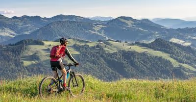
Imagine cycling with the soothing sight of a river to your side.
Wouldn't that be a dream ride?
Well, it's not as far-fetched as you might think.
Across the United States, there are many bike paths that run along picturesque rivers, offering both recreational and endurance cyclists the chance to enjoy nature's serenity while pedaling through diverse landscapes.
Ready to explore America's riverfronts?
These bike paths provide scenic views, fresh air, and a delightful change of pace from the average urban cycle route.
From winding trails through historical sites to expansive paths spanning multiple states, there's a river route for cyclists of all skill levels.
You're in for a treat with this curated list of the best bike paths along rivers.
As an enthusiastic cyclist myself, I've either ridden on these trails or spent ample time researching them to ensure you get the most accurate and practical information.
Whether you're planning a short recreational outing or an epic long-distance trek, this guide will steer you to the best spots where pedal power meets the peace of the river.
American River Bike Trail (California)

Hey there, fellow bike enthusiast!
Have you heard about the American River Bike Trail in sunny California?
Picture this: a scenic 32-mile stretch along the bustling American River, all paved and perfect for a ride any day of the year.
Whether you're pedaling from Discovery Park in downtown Sacramento or heading towards Beal's Point in Folsom, there's no shortage of gorgeous river vistas and friendly pit stops.
What's the vibe?
It's all about variety here!
You could be zipping through suburban settings or cruising by tranquil parklands—each turn brings a new backdrop.
And if you're yearning for a mix, Folsom Lake’s southwestern banks throw in a tranquil escape.
- Length: 32 miles
- Surface: Paved
- Access Points: Discovery Park, various parks in the American River Parkway
Thinking about stopping along the way?
You've got choices galore!
The trail kisses many parks, including:
- Discovery Park
- Howe Avenue River Access
And for those of you who might want a break from paved paradise, sneak a peek at some dirt paths that veer off into the levees.
A little adventure never hurt, right?
So, whether you're all about the fast lane or just cruising, this trail is your oyster.
Helmet on, and happy riding!
Katy Trail State Park (Missouri)

Have you been dreaming of a picturesque bike ride along a river?
Let me paint a scene: the Katy Trail State Park in Missouri might just be your next adventure.
Imagine pedaling along the Missouri River, immersed in the natural beauty and sprinkled with a dash of history.
- Length: 240 miles (Wow, that's long!)
- Terrain: Mainly flat, with a crushed limestone surface
- Scenery: River views, historic towns, wine country
Why should you add this to your biking bucket list?
- Trail Difficulty: Perfect for all skill levels, the trail's gentle grades make for an easy ride that lets you soak up the sights without huffing and puffing.
- History Along the Way: It's not just a trail; it’s a trip through time. The path traces the footsteps of Lewis and Clark and takes you through charming towns with friendly locals.
Did I mention the amenities?
You'll find:
- Excellent bike repair stations
- Clean restrooms
- Picnic spots for a delightful outdoor lunch
And if you're wondering about ratings:
- Trail Ratings: Katy Trail: Greens Bottom Road to Missouri Research Park Trail scores a fabulous 4.5 stars from fellow bikers.
- The Most Popular Segment: Weldon Spring to Augusta, with a 4.7-star endorsement.
Now, you might be thinking about where to rest after a long day's ride.
Well, camping spots are available along the trail, giving you a chance to stargaze and unwind in nature’s embrace.
Heading out on the Katy Trail?
Don't forget to pack your favorite snacks, plenty of water, and your curiosity.
Ready for the ride of a lifetime?
Happy biking!
Hudson River Greenway (New York)

Have you ever wanted to ride your bike along the mighty Hudson, with a gorgeous skyline unfurling next to you?
If so, the Hudson River Greenway is your dream come true!
This fascinating 11-mile stretch is the perfect recipe for a fun day out, whether you’re getting your daily exercise or just out for a leisurely ride.
Quick Facts:
- Length: 11 miles
- Surface: Paved
- Difficulty: Easy to moderate
- Accessibility: Highly accessible from multiple cross streets downtown
Nestled along the western shores of Manhattan, this bike path is not only the longest stretch of the Manhattan Waterfront Greenway, but it's also a key segment of the 32-mile round-the-island route.
To everyone’s delight, it's specifically carved out for bikes, skateboards, and rollerbladers, which means you can enjoy your ride without the worry of traffic!
Have you ever commuted on a bike path with a view?
Well, here, it's the norm.
Both commuters and weekend pedal pushers love the Hudson River Greenway for its scenic vistas of the river and New Jersey’s skyline.
Plus, don't miss out on the views of the well-groomed parks you'll zip by!
-
Trail Access Points:
-
Battery Park (south)
-
Dyckman Street (north)
Need a break or a bike?
No problem!
Stop by Hudson River Park’s Pier 84, where you can rent bikes and gear up for the ride.
And, if you're wondering about the crowd, the path can get busy as you approach downtown, so brace yourself for some biking camaraderie!
So, ready to explore one of New York's finest bike paths?
Your adventure along the Hudson awaits!
Mississippi River Trail (Various States)

Have you ever imagined pedaling over 3,000 miles with the legendary Mississippi River as your travel buddy?
As one of the most scenic trails in America, the Mississippi River Trail covers a vast stretch from the river's headwaters in Minnesota's Itasca State Park down to the sultry deltas of Louisiana.
How about this for size—the trail snakes alongside the river, giving you over 70 miles of connected biking bliss from Memphis to Marianna, Arkansas!
- Starting Point: Itasca State Park, Minnesota
- Ending Point: The river's delta, Louisiana
- Total Distance: 3,000+ miles
Packed with jaw-dropping views, this trail weaves through 10 states—each offering its own unique slice of the Mississippi River tableau.
Imagine ticking each state off your list.
What's a better way to sample the heart of America than on two wheels?
The MRT isn't just a single-threaded trail; it's a network of bike-friendly roads and dedicated paths.
Guess what?
In Minnesota, there's a 600-mile segment just waiting for you to explore, and it even includes alternative routes that can push your journey beyond the 800-mile mark.
Now, that's what you call a serious ride!
- Minnesota Segment: Roughly 600 miles
- Additional Routing: Up to 800+ miles
Don't fret about logistics.
There are resources like the "Bicycling Guide to the Mississippi River Trail" and detailed state guides to help you plot your course.
These guides can be real life-savers, pointing out the best spots for a break or where to catch that picture-postcard sunrise you'll brag about for years to come.
Here's a quick rundown:
- Big River Crossing: Longest public pedestrian bridge across the Mississippi
- Illinois Trail Guide: Your key to a 585-mile picturesque river route
Last but not least, did you know parts of the MRT are so special they've been designated National Millennium Trails?
Now that's a story to share at your next pit stop!
So, are you ready to embark on an epic journey down the spine of America?
Because the Mississippi River Trail is waiting right there, under those cycling shoes of yours.
Let's get those wheels spinning!
Chicago Lakefront Trail (Illinois)

Have you heard about the Chicago Lakefront Trail?
It's an 18-mile stretch along picturesque Lake Michigan, and although it's not hugging a river, the waterfront vibe is just as refreshing.
Imagine cycling with the breeze in your hair, the Chicago skyline on one horizon, and the endless lake on the other—tempting, isn't it?
Length: 18 miles
Starting Point: E. 71st.
St. and S.
South Shore Dr.
Ending Point: W.
Ardmore Ave. and N.
Sheridan Road
The trail is a scenic route lined with an array of parks and beaches that provide spots for a quick dip or a lazy picnic.
Here's what you might love about this trail:
- Accessibility: It's open for bikers, joggers, and even skateboarders.
- Views: Every pedal comes with a free show of natural beauty and cityscapes.
- Recreation: You're never too far from a spot to relax or grab a bite.
Starting at E. 71st.
St., you weave through bustling beaches and serene parks until you reach W.
Ardmore Ave.
Along the way, each park—like the popular Gompers Park—tells its own story, and who knows, you might find your new favorite spot!
Remember, whether you're a seasoned cyclist or someone just looking to stretch their legs, this trail has a little something for everybody.
So, grab your bike (or rent one nearby), plenty of water, and set off on an urban adventure you won't forget.
And hey, don't race through it—take your time to soak in those gorgeous views.
Ready to ride?
Capital Crescent Trail (Maryland and Washington, D.C.)

Have you ever pedaled along a path where cityscapes and natural beauty blend seamlessly?
Let me introduce you to the Capital Crescent Trail, a favorite for both locals and tourists looking to soak in some scenery with their cycling.
Running from the vibrant streets of Georgetown, Washington, D.C., all the way to Silver Spring, Maryland, this trail stretches for 11 miles and offers a feast for the senses.
Alongside the serene Potomac River, you'll catch golden sunsets that dip over water and inspiring views of the historical C&O Canal.
Here are some quick facts about the trail:
- Length: 11 miles
- Starting Point: Georgetown, Washington, D.C.
- Ending Point: Silver Spring, Maryland
- Activities: Biking, walking, skating, and bird-watching
The Capital Crescent Trail isn't just a place for a good workout; it's also steeped in history, tracing the route of the old Georgetown Branch of the Baltimore and Ohio Railroad.
Imagine riding your bike over tracks that once echoed with the rumble of freight trains!
Why is it among the best?
- Scenery: It offers a unique vantage point of the D.C. landscape.
- Accessibility: Trailheads and maintenance, like bike repairs and water stations, are conveniently located.
- Versatility: Perfect for an easy ride or for those who fancy picking up the pace.
And if you're worried about forgetting a snack or need a sudden bike fix, rest assured, as there are ample amenities along the way.
So what are you waiting for?
Grab your bike, some pals, or just your headphones and enjoy one of the best bike paths along a river the Capital has to offer.
Schuylkill River Trail (Pennsylvania)

Have you ever dreamed of pedaling along a trail that weaves through the heart of American history and breathtaking landscapes?
Well, say hello to the Schuylkill River Trail in Pennsylvania!
This gem of a bike path stretches a solid 75 miles, guiding you from the vibrant streets of Philadelphia to the charming town of Pottsville.
What's in store for you along the way?
Well, it's a delightful mix of urban buzz and serene countryside, offering both the thrill of the city and the calm of nature.
Picture this:
- Cityscapes & Skylines: Starting in Philly, the trail lets you admire the city's lively riverbank scenes.
- Historic Towns: Imagine pedaling through places where pivotal moments in history unfurled.
- Green Retreats: Need a breather? The trail is dotted with parks perfect for a picnic break.
- Industrial Heartland: Don't be surprised to find remnants of America's industrial revolution whispering tales of yesteryear.
Feeling curious about what else you can expect?
How about:
- Crushed Stone & Paved Paths: Catering to your riding comfort, the trail has both smooth paved sections and more rustic crushed stone parts.
- Evidence of Centuries: Keep your eyes peeled for historical markers and sites. It's like riding through a living museum!
Whether you're in it for a leisurely ride or a cycling marathon, the Schuylkill River Trail is your scenic ally.
Remember, you've got a whopping 75 miles to explore, so why not plan multiple trips to fully savor the experience?
So, grab your bike (or rent one nearby), call up some friends, and set out on one of Pennsylvania's pride and joys.
Who knows the stories and sights that await you along the Schuylkill River Trail?
Ohio & Erie Canal Towpath Trail (Ohio)

Have you ever wondered what it's like to follow in the footsteps of history while enjoying some stunning river views?
Say hello to the Ohio & Erie Canal Towpath Trail!
This 87-mile treasure stretches from the vibrant city of Cleveland all the way to New Philadelphia, letting you soak in a bit of history and nature on two wheels.
What's Special About It?
- Scenic Views: You're in for a treat with captivating sights of the Cuyahoga and Tuscarawas Rivers.
- Historic Route: Trace the same path mules once trekked to pull canal boats.
- Accessible: The flat terrain includes a mix of compacted, crushed limestone and pavement, making it wheelchair-friendly.
Craving Some Nature?
The trail meanders through the lush Cuyahoga Valley National Park.
Think of the serene landscapes you'll cruise by — it's a slice of peace away from the city bustle.
Stats at a Glance:
- Length: 87 miles, connecting Cleveland to New Philadelphia
- Counties: Cuyahoga, Summit, Stark, Tuscarawas
- Accessibility: Mostly lit and cleared of snow in winter
Curious about facilities and planning?
Some parts are so well-lit and maintained that nighttime rides or winter cycling is an absolute go.
Should you decide to embark on a multi-day journey, a simple call to the park's Communications Center helps safeguard your vehicle.
Ready for an Adventure?
Just imagine: you're pedaling through history, rivers gently flowing beside you, and each turn brings a new discovery.
Whether you're in it for a quick ride or a long-haul journey, the Ohio & Erie Canal Towpath Trail is a cyclist's haven.
Grab your bike, and let's hit the trail, shall we?
Greenbelt Park (Idaho)

Ever pedaled along a river and felt like you're cruising through a postcard?
Well, buckle up your helmet because the Boise River Greenbelt is your chance to live that dream.
Picture this: 25 miles of smooth path weaving through Boise, Idaho, with the gentle Boise River as your trusty sidekick.
Cool, right?
Now, imagine taking a pit stop at one of the over 850 acres of parks this path connects.
You've got scenic views, a chance to spot songbirds, and if you're lucky, a bald eagle or two in the winter.
Eagles!
In the wild!
Just doing their majestic thing!
And hey, are you into wildlife watching?
Give yourself the best shot by hitting the trail early morning or cruising along as the sun dips down.
It's like nature's own reality show, except you're part of the action.
But what about the biking itself, you ask?
Well, it's not just a straight shot from A to B.
This trail zigzags through the heart of Boise, linking neighborhoods, downtown buzz, and peaceful nature spots.
It's not just about getting from place to place; it's about enjoying every pedal of the journey.
You'll ride by surfers riding "The Wave" at the Boise Whitewater Park and zip through the "Ribbon of Jewels," parks that are strung along the river like, well, jewels.
So pack your water bottle, maybe a picnic, and don't forget your sense of adventure.
Let's get those wheels spinning!
Arkansas River Trail (Arkansas)

Have you ever cycled somewhere that took your breath away with every turn?
If not, it sounds like the Arkansas River Trail is calling your name.
This phenomenal 88-mile loop meanders through Little Rock, North Little Rock, and beyond, escorting you alongside the Arkansas River with enchanting river views that are sure to make your ride memorable.
Did you know that among the sights you’ll encounter is the Big Dam Bridge?
It’s not just a clever name—it's the nation’s longest bridge designed specifically for cycling and walking enthusiasts.
This architectural marvel is a high point, literally and figuratively, of the trail!
Here’s a fun snapshot of the trail highlights:
- Total Length: A whopping 88 miles of multi-use paths
- Core Loop: A 15.6-mile stretch connecting key points of the trail
- Key Landmarks: The Big Dam Bridge, Clinton Presidential Bridge, and numerous parks
- Best Activities: Biking, birding, and even a serene hike if you're up for it
Cycling or strolling, you can start your journey in the bustling Little Rock River Market, with the trail unfolding on both sides of the river.
Isn't it cool how you can cross the river without ever sharing the road with cars?
Accessibility?
Check!
You'll find convenient Bike Fixit Stations at Two Rivers Park, making sure you're good to go.
What’s the best time to enjoy the trail, you ask?
Anytime!
Whether it’s an early morning ride to catch the sunrise or an evening jaunt to unwind, the Arkansas River Trail provides a perfect slice of outdoor paradise.
So, grab your helmet and hit the trail, because adventure awaits you at every mile!


.avif)
